Honoring a Legacy: The Story Behind Greggar's Map
Jerod ArlichShare
In the heart of the Boundary Waters Canoe Area Wilderness (BWCA), where the spirit of adventure whispers through the pines and dances atop the pristine waters, lies a story of heritage, exploration, and legacy. It's a story that True North Map Co. is proud to share through the release of "Greggar's Map," a tribute to the late Brule resident, Greggar Isaksen, and a nod to the adventurers who came before us.
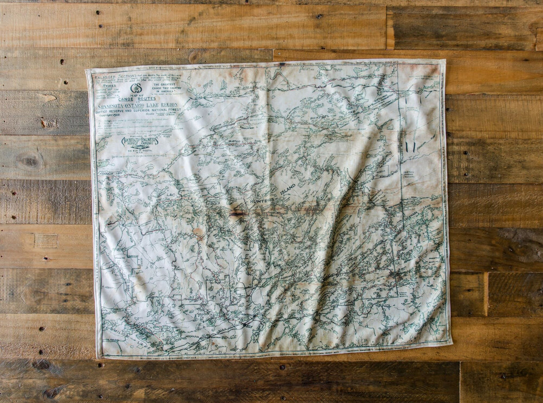
Greggar Isaksen was not just a man of the wilderness; he was a steward of history, a bridge between generations, and an embodiment of the adventurous spirit that defines the Boundary Waters. The map that bore his name, "Greggar's Map," is a replica of the 1928 Canoe Country Map, a cherished artifact that guided many through the intricate waterways and untouched landscapes of what is now known as the BWCA.
The original map, a linen masterpiece, was purchased by Isaksen's parents at a local outfitter in 1933. It was more than a navigational tool; it was a family heirloom, rich with hand-drawn lakes, detailed information on portages, rapids, and unique author notes that captured the essence of the wilderness at that time. Greggar grew up paddling the Boundary Waters, with this map as his guide, exploring the same lakes that Native Americans, explorers, and previous generations had traversed.
Reflecting on the significance of "Greggar’s Map," it's clear that while technology and navigation tools have evolved, the landscape has remained largely unchanged. This map serves as a bridge for history buffs and adventurers alike, connecting us with the past and the countless stories etched into the landscape of the BWCA.
Before his passing, Greggar had the foresight to share his legacy with the world. He had previously printed replicas of his map on paper, primarily for decorative purposes, to adorn the walls of cabins throughout the north country. However, upon discovering True North Map Company and its innovative approach to creating fully functional, navigational, and durable maps printed on moisture-wicking fabric, Greggar recognized an opportunity to introduce a new generation to the wonders of the BWCA, just as he had experienced them.
True North Map Co.'s reproduction of the 1928 map honors Greggar's memory and his family's legacy. It's made with the modern adventurer in mind, using rugged Northwoods-friendly fabric that withstands the elements, ensuring that Greggar's spirit of exploration lives on. It's a testament to the timeless allure of the Boundary Waters and a tribute to those who cherish its history and natural beauty.
Greggar's story is one of passion, preservation, and passing on the torch of adventure. Through "Greggar's Map," his legacy will continue to inspire and guide adventurers as they navigate the storied waters of the BWCA. In doing so, we not only honor his memory but also connect with the rich tapestry of history and wilderness that defines this extraordinary place.
As we unfold Greggar's Map and chart our course across the Boundary Waters, let us remember the legacy of Greggar Isaksen — a man whose love for the wilderness and dedication to preserving its history enriched the lives of all who knew him and will continue to inspire future generations of explorers.
-----
In Greggar's own words:
History Of The 1928 Map
In the summer of 1933 my parents, Leon and Edith Isakseri of Madison, Wisconsin and two other couples spent 4 weeks canoeing.the Hunter's Island route in Canada's Quetico Provincial Park.
Beginning in Madison, they drove to Duluth and on to Winton to pick up equipment from Border Lakes Outfitting Company. Then onto Fort William/Port Arthur to board the railroad for the trip west to the train station at Quetico.
According to the old photos they paddled to a beautiful cabin on an island in Windigoostigwan Lake. Unfortunately the cabin had only two cots and a table. My parents drew the floor. The cabin was owned by Professor Edmund A. Ross of the Sociology Department at the University of Wisconsin, Apparently the cabin was later abandoned and it reverted to the Canadian government. I have some old photos of the cabin and of the rest of their trip. I will probably give them to the French Lake Center of the Quetico Provincial Park. There also are two reels of 16 mm movie film that will go to the park museum. We are in the process of converting the film to VHS video for use by anyone or canoe shop, etc.
This map might be the last! Someone may have another in their closet, but nobody.in Ely, Duluth, Grand Marais or in the Quetico Park headquarters had ever seen or heard of another.
The original was printed on linen. My parents bought it for $2.50 - quite a sum in 1933! It is my guess that they purchased the map at Border Lakes in Winton. I do not know if Sigurd Olson owned Border Lakes at that time.
The map was used often. I. can remember my father, In the stern of the canoe, carefully unfolding and refolding the linen on our many trips together during the 1950's. Read the notes...the history... the names of lakes...sand beaches... the location of a ranger cabin.
Framed, the map Is very distinctive! Quite a gift for the Quetico-Superior buff!
Thanks to the constant encouragement of a fellow canoeing friend, I finally made the decision to do the four color reprinting and allow this map's history to go forth! I trust that you will share many hours of enjoyment from this reprint. I certainly have had a great deal of pleasure bringing It back to the greatest canoe country In North America!